
Adelaide’s festival season reawakens the city. Can it also inspire a reimagining?
Each year in the South Australian capital city of Adelaide, residents and those visiting from afar get a taste of what they’re missing out on (well, what the Adelaideans are missing, at least). To celebrate and capitalise on occasions such as Lunar New Year and the Adelaide Fringe Festival, streets are closed to car traffic, restaurants, vendors and street performers spill out and set-up, and people on-foot reclaim their streets.
These street parties are joyous events, and the sense of vibrancy and ownership that they create is invigorating, if short-lived. Sadly, the pedestrianisation of precincts such as Gouger Street and Rundle Street, Vardon Avenue and Ebenezer Place is restricted to a couple of months a year and given snappy names like ‘East End Unleashed’ (Figure 1).
While the sense of vibrancy and ownership seem extra special when people are only permitted to enjoy them during certain times of the year, they needn't be saved for special occasions. The economic, social, and environmental benefits of giving streets back to people can and should be enjoyed year-round.
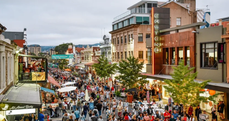
Figure 1 - Rundle Street closure (opening?)
This is by no means a new idea – the movement can be traced back to 1990s London, while more recent examples include Paris’ city-wide efforts, and Sydney’s George Street transformation.
But while considering George Street in isolation provides a fantastic example of what can be achieved along one street, for the idea to truly meet its potential it must impact many places in a coordinated way.
Strategic planning is therefore required. By thinking about what makes a city work, what affects people’s daily lives, and critiquing existing solutions, planners can approach this land-use challenge with the necessary values in mind (Thompson and Maginn 2012).
Central to this idea is governance and the allocation of resources. Fundamentally, it’s about the public interest and deciding who, or what, we’re giving the rights to the city to. Inescapable is the need to view planning issues through the lens of climate change; however, it is not the only lens and as Welch (2021) argues, simply replacing internal combustion engines with electric vehicles won’t save us.
We need to redesign our spaces for people.
Reallocation of space
Pedestrianising a few streets in Adelaide without also altering the transport status quo would be missing the point. To truly reclaim the streets, people need to be able to travel to and within the city without reliance on cars. This is because, at minimum, a parked car requires three times as much space as public transport, and ten times as much as a bicycle (Nello-Deakin 2019).
To enable people to use and enjoy city streets, this space must be reallocated to wide pedestrian areas, cycling infrastructure, and public transport infrastructure. By doing so, further opportunities to improve the built environment are presented, such as spaces for greening and increasing canopy cover, spaces for alfresco dining, and spaces for social interaction.
The bigger picture is what makes this idea strategic.

Figure 2 - Windsor Street Linear Reserve
Just outside of the Adelaide CBD, the Windsor Street redevelopment (Figure 2) provides an example of grasping these opportunities. The City of Unley leveraged an existing infrastructure project – the replacement of an open drain with box culverts – to provide a linear reserve and walking trail with 15,000 plants from 84 locally native species, sitting alongside a low-traffic neighbourhood cycling route.
Strategic planning and good governance are exemplified here. A focus on amenity and having a vision that incorporates environmental and social outcomes into urban change are key components of strategic planning (Buxton et al. 2016), while successful project implementation relies on achieving public and political support (Hersperger et al. 2018).
Here, funding from the state Planning and Development Fund, ownership by council staff, and the involvement of residents through consultation and a staged approach to implementation are all identified as contributing to the success of the project.
Reimagining Adelaide
All of this raises questions around whose responsibility it is to reclaim the streets. Who owns the space? Which tier of government – state or local – is going to drive a reimagining of our streets in the public interest?
Local government is primarily responsible for local roads and the design of streetscapes and public spaces, while state government is responsible for arterial roads and the public transport network. Thus, buy-in from both tiers and collaboration between the two is required.
In Adelaide, recent history suggests it is local government that is leading the way. However, from a state government perspective, with its imperative to create a state brand (Williams and Maginn 2012), liveable streets that appeal to the world must be of benefit, too.
When we consider the benefits of street closures during Adelaide’s festival season, we must ask why we would limit this benefit to a fraction of the year. From a governance perspective, we should be planning with the public interest at the forefront. From a strategic planning perspective, we should be planning to maximise environmental, social, and economic outcomes.
Reclaiming streets provides space for greening and the provision of shade, as well as integrating regenerative natural systems (du Plessis 2012). Encouraging active mobility through the provision of good walking, cycling, and public transport infrastructure can create a healthier population (Mason 2000), as well as a more equitable and cohesive one (Creutzig et al. 2020). At the same time, people on foot or on bike are better for local businesses.
For those that must drive, fewer cars on the road means less congestion.
The challenge for urban planners is how to achieve reallocation of space without encountering major resistance (Gössling 2020). The idea of ‘hacking’ as a mode of governance – new creative ways of engaging, and experimentation – as proposed by Chandler (2018), could provide a way forward.

Figure 3 – Main Streets Revitalisation
The City of Adelaide’s Main Streets Revitalisation projects (Figure 3) offer a local example. The use of temporary footpath extension trials enables a kind of experimentation, a chance for the public to get a taste of the changes and their benefits. By engaging the public in the shaping of their space, and allowing time for the benefits to be felt and understood before permanent implementation, backlash to the changes may be avoided and a path for further alterations created.
To this end, it is promising that within the draft Master Plan for the revitalisation of Hutt Street, design principles include:
“… reallocation of public space from vehicle use (parking and traffic lanes) to achieve a more equitable allocation of public space and a good balance between transport modes, trees/landscaping, [and] outdoor dining opportunities, to support businesses and enhance social interactions, and provide safer movement.”
This language is not insignificant and is indication that these ideas are becoming increasingly mainstream.
Perhaps a reimagination of Adelaide isn’t so far away.
References
Adelaide Economic Development Agency (2023) East End Unleased, Adelaide Economic Development Agency website, accessed 24 March 2023, experienceadelaide.com.au/east-end-unleashed/
Blanco JR (2013) ‘Reclaim the streets! From local to global party protest’, Third Text, accessed 25 March 2023, thirdtext.org/reclaim-the-streets
Buxton M, Goodman R and Moloney S (2016) ‘City growth, sustainability and planning’, in Planning Melbourne: Lessons for a Sustainable City, CSIRO Publishing, Melbourne
Chandler D (2018) Ontopolitics in the Anthropocene: An introduction to mapping, sensing and hacking, Taylor and Francis Group
City of Adelaide (2022) Main Streets Revitalisation, City of Adelaide Your Say website, accessed 21 March 2023, yoursay.cityofadelaide.com.au/mainstreets-2022
City of Adelaide (2022) Hutt Street – Main Street Revitalisation, City of Adelaide Your Say website, accessed 21 March 2023, yoursay.cityofadelaide.com.au/hutt-street
City of Sydney (14 June 2022) George Street south transformed into a pedestrian boulevard, City of Sydney website, accessed 21 March 2023, news.cityofsydney.nsw.gov.au/articles/george-street-south-transformed-into-a-pedestrian-boulevard
Clements R, Taylor E and Croeser T (3 December 2020) ‘Why Australian cities need post-COVID vision, not free parking’, The Conversation, accessed 26 March 2023, theconversation.com/why-australian-cities-need-post-covid-vision-not-free-parking-150380
Creutzig F, Javaid A, Soomauroo Z, Lohrey S, Milojevic-Dupont N, Ramakrishnan A, Sethi M, Liu L, Niamir L, Bren d’Amour C and Weddige U (2020) ‘Fair street space allocation: ethical principles and empirical insights’, Transport Reviews, 40(6):711-733
Du Plessis C (2012) ‘Towards a regenerative paradigm for the built environment’, Building Research & Information, 40(1):7-22
Gössling S (2020) ‘Why cities need to take road space from cars and how this could be done’, Journal of Urban Design, 25(4):443-448
Hersperger AM, Oliveira E, Pagliarin S, Palka G, Verburg P, Bolliger J and Grădinaru S (2018) ‘Urban land-use change: The role of strategic spatial planning’, Global Environmental Change, 51:32-42
Hidalgo D (15 July 2020) ‘More bicycles, slower speeds, a more liveable city: Paris Mayor Anne Hidalgo plans an ambitious second term’, The City Fix, accessed 21 March 2023, thecityfix.com/blog/bicycles-slower-speeds-livable-city-paris-mayor-anne-hidalgo-plans-ambitious-second-term-dario-hidalgo/
Mason C (2000) ‘Transport and health: en route to a healthier Australia?’, The Medical Journal of Australia, 172(5):230-232
Nello-Deakin S (2019) ‘Is there such a thing as a ‘fair’ distribution of road space?’, Journal of urban design, 24(5):698-714
South Australian Department for Environment and Water (2017) Green Infrastructure Case Study: Windsor Street Linear Reserve, accessed 21 March 2023, https://cdn.environment.sa.gov.au/landscape/docs/hf/green-infrastructure-windsor-st-case-study.pdf
Thompson S and Maginn P (2012) ‘What is planning?’, in Planning Australia: An Overview of Urban and Regional Planning, Cambridge University Press
Welch T (17 November 2021) ‘Electric cars alone won’t save the planet. We’ll need to design cities so people can walk and cycle safely’, The Conversation, accessed 21 February 2023, theconversation.com/electric-cars-alone-wont-save-the-planet-well-need-to-design-cities-so-people-can-walk-and-cycle-safely-171818
Williams P and Maginn P (2012) ‘Planning and Governance’, in Planning Australia: An Overview of Urban and Regional Planning, Cambridge University Press
Figure 1 – Rundle Street closure (opening?), Joy and bedlam as East End is Unleashed, InDaily website, accessed 24 March 2023, indaily.com.au/news/sponsored-content/2020/02/27/joy-and-bedlam-as-east-end-is-unleashed/
Figure 2 – Windsor Street Linear Reserve, Flannery JA and Smith KM (2015) ‘Windsor Street Linear Trail’, in Eco-Landscape Design, Springer
Figure 3 – Main Streets Revitalisation, Hutt Street – Main Street Revitalisation, City of Adelaide Your Say website, accessed 21 March 2023, yoursay.cityofadelaide.com.au/hutt-street
Lachlan Pink is an environmental manager and second year Master of Urban Planning student at RMIT. He is interested in improving ecosystem and human health through the strategic planning and design of our cities.